MA UD Urban Design Thesis
The MA Urban Design is organised in two parallel taught modules followed by the Thesis module. The first two modules, the urban design studio www.ma-ud-design.blogspot.com as well as the lecture and seminar series in urban theory www.ma-ud-theory.blogspot.com, work hand in hand. They form a common educational platform for personal research, explorations and design. After successful completion, student begin the Thesis work. It is self-directed and comprises individual designs and theoretical writings in an interdependent manner.
During the thesis component, students consolidate their main design project and expand it with a personal focus on an area of particular interest. This aims at developing a special knowledge, by adding to the field of urban design in an original manner.
The Thesis work consists of two parts. Students write and compile an 8000-10000 word document, where both critical design and theory invigorate each other. This allows each student to structure the work intellectually and practically, by setting it in relation to other urban studies. As further part of this interdependent work, students refine their design portfolio for the final presentation.
Beside masters assessment criteria and learning outcomes, the work is assessed against students‘ self defined objectives, acknowledging personal aspirations and the very nature of each individual work.
2008-09 Zaher El Afiouni
Thesis - 'Overlapping Grains' in the Lower Lea Valley London
MA Alternative Urbanisms - 2008/09 - Design and Theory Part, 04 October 2009
MA Alternative Urbanisms - 2008/09 - Design and Theory Part, 04 October 2009

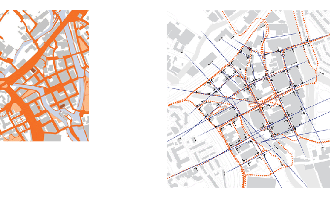
Model of unfolding vistas and possible movements pattern in Shoreditch, London
The initial research explored existing urban forms, vistas and movements in Shoreditch, Central London. Each public space has a particular configuration, allowing users to navigate through space in different ways. Some forms enhance legibility, others don't. The work looked at a sequence of more legible spaces and a whole succession of unfolding vistas alongside possible movement pattern. For example, a vista along a street closes in an angled facade. This might allow an assumption that the public space might continue. By walking towards the angled facade, further public space opens up and a new focus point comes into vision. Again this allows further navigation and so on. In his book The Concise Townscape, Gorden Cullen refers to this also as 'serial vision'. It is a fundamental design tool for existing urban conditions or more complex urban proposals.
Main design proposal for Sugar House Lane, plan and vistas
The proposal work focuses on Sugar House Lane, a former industrial island in the Lea Valley in East London. The strategy is twofold. A new hybrid building typology overlaps two prevailing building grains of the area, large industrial sheds and small housing units. The industrial units form a base and the smaller units are situated on top and on the side. Residents can modify the housing units, within a set of rules and according to a patternbook. The principles expand on the case study of Elemental Chile. It is a low-cost housing scheme that allows residents to expand their housing units within a given framework. The growing and potentially also shrinking of housing units responds to changing family and income pattern.
The individual urban blocks are subject to larger considerations. Unfolding vistas and an urban envelope allow the proposal to weave into the existing context. The project is both, a framework for future growth and a unique place.

Urban envelope studies, sketch and model work for the design proposal
Zaher El Afiouni: "How do you read architecture within the will to deliver an art composition?"
Rodrigo Perez de Arce: "As John Turner says housing is a process it’s not an object. Accordingly, if we modify the process, we are also modifying the meaning of the object. Housing was always a process, it was not something to be seen only through the eyes of composition, it was not primarily a formal composition...it was dynamic."
Zaher El Afiouni in conversation with Rodrigo Perez de Arce, 2009.

Proposed rules for urban blocks, Overlapping Grains
2008-09 Yemin Yin
Thesis - 'Upper Ground' in the Lower Lea Valley London
MA Alternative Urbanisms - 2008/09 - Design and Theory Part, 04 October 2009
MA Alternative Urbanisms - 2008/09 - Design and Theory Part, 04 October 2009
Strategic timeline and phasing by Yemin Yin, 2009
The project focuses on Sugar House Lane in the Lea Valley in East London. It takes distinct conditions as a starting point. The urban fabric is fragmented around this industrial island, as railroads, motorways, canals and rivers cut through the city. In addition, an agglomeration of very large disused industrial buildings forms an almost continuous roofscape. Both conditions offer potential for an unusual typology, responding to the demand for access and parks as well as spaces of work, light industry and inhabitation.

Existing vistas and proposed urban plan by Yemin Yin, 2009
The design proposal formulates principles for an upper ground. It is bridging over different forms of infrastructure and connects inhabitable roofscapes, combining diverse building typologies. This allows urban life on street level, where the city has diverse addresses. In addition, a continuous upper ground offers functions, like walkways, playgrounds and parkland above. The project is a manual for a collective process, mediating individual interests and common spaces for an enjoyable urban life. Both grounds add to the diversity and intensity of urban experience, rather than distracting from one another. After all, a city is a place, where things happen simultaneously.

Framework rules for urban block developments - party walls, envelopes, circulation, green spaces and light
"The act of crossing space stems from the natural necessity to move to find the food and information required for survival. But once these basic needs have been satisfied, walking takes on a symbolic form that has enabled man to dwell in the world. By modifying the sense of the space crossed, walking becomes man‘s first aesthetic act, penetrating the territories of chaos, constructing an order on which to develop the architecture of situated objects. Walking is an art from whose loins spring the menhir, sculpture, architecture, landscape. This simple action has given rise to the most important relationship man has established with the land, the territory."
Francesco Careri, Walkscapes (2002)
Francesco Careri, Walkscapes (2002)

Perspective over public roofscape by Yemin Yin, 2009
"In this space of encounter walking is useful for architecture as a cognitive and design tool, as a means of recognizing a geography in the chaos of peripheries, and a means through which to invent new ways to intervene in public metropolitan spaces, investigate them and make them visible. The aim is not to encourage architects and landscape architects to leave their drawing boards behind, shouldering the backpack of nomadic transurbance, nor is it to theorize a total absence of path to permit the citizen to get lost, although often errare could truly be seen as a value instead of an error.

Upper Ground walking experience, Yemin Yin, 2009
The aim is to indicate walking as an aesthetic tool capable of describing and modifying those metropolitan spaces that often have a nature still demanding comprehension, to be filled with meanings rather than designed and filled with things. Walking then turns out to be a tool which, precisely due to the simultaneous reading and writing of space intrinsic to it, lends itself to attending to and interacting with the mutability of those spaces, so as to intervene in their continous becoming by acting in the field, in the here and now of their transformation, sharing from the inside in the mutations of these spaces that defy the conventional tools of contemporary design. ..."
Francesco Careri, Walkscapes (2002)
2008-09 Colin O'Sullivan
Thesis - Housing Framework, Savage Garden in Beckton London
MA Alternative Urbanisms - 2008/09 - Design and Theory Part, 04 October 2009
MA Alternative Urbanisms - 2008/09 - Design and Theory Part, 04 October 2009

Savage Garden Close, Beckton/ London, 2008
The work is located in Beckton next to the University of East London. Beckton is part of suburban redevelopments in the London Docklands, car-dominant and typical for the 1980s.
The project addresses the redevelopment of public space and private house extensions. The redevelopment of public space aims at enhancing the usability, accessibility and legibility to create sociable spaces for the whole community. The private house extensions would allow people to shape their living environment according to individual needs. In the project, each owner of a relatively small house is enabled to increase space and also property value, actually by planning alone as well as by physical extensions.
The project addresses the redevelopment of public space and private house extensions. The redevelopment of public space aims at enhancing the usability, accessibility and legibility to create sociable spaces for the whole community. The private house extensions would allow people to shape their living environment according to individual needs. In the project, each owner of a relatively small house is enabled to increase space and also property value, actually by planning alone as well as by physical extensions.

Existing and proposed urban plan by Colin O'Sullivan, 2008
"The ’close’ is that place the stranger does not enter; a place that in many ways is semi-private in nature. This condition when reproduced en masse provides a section of the city with a place, which while appearing open, is in operation the very opposite. The social outcomes of community making, social interaction and integration that were Howard’s hope could never develop in this spatial construct. The close has become ubiquitous in cities. [...]
The Beckton estate can be seen as adopting the most attractive and immediately profitable elements of Howard’s proposals. It conforms with some of the specifics, but none of the spirit of the Garden City. It adopts the ’close’ arrangement; separates functions and removes cars but in its separation of functions it becomes entirely mono-functional. The cul-de-sacs serve only to spatially segregate residents from one another and from the city outside. The removal of cars in the absence of any function but residential equals the removal of life from the area. Thus I argue, that it is the misinterpretation, rather than the adoption, of the Garden City idea which has contributed to the spatial dysfunction of this part of Beckton."
The Beckton estate can be seen as adopting the most attractive and immediately profitable elements of Howard’s proposals. It conforms with some of the specifics, but none of the spirit of the Garden City. It adopts the ’close’ arrangement; separates functions and removes cars but in its separation of functions it becomes entirely mono-functional. The cul-de-sacs serve only to spatially segregate residents from one another and from the city outside. The removal of cars in the absence of any function but residential equals the removal of life from the area. Thus I argue, that it is the misinterpretation, rather than the adoption, of the Garden City idea which has contributed to the spatial dysfunction of this part of Beckton."

Model of possible urban growth by Colin O'Sullivan, 2008
During the Collaborative Design Workshop www.cd-g-workshop.blogspot.com in August, our invited experts and the students discussed a series of design tools.
The overall scheme maintains its long-term quality with the application of a pattern-book, describing a visual and material framework. The scheme require an involvement of a third party to negotiate initial collaborative design, decision making processes, planning application and implementation. The public space management and individual ‘retrofitting’ open up questions of local community involvement and sense and sensibility of current local planning.
The overall scheme maintains its long-term quality with the application of a pattern-book, describing a visual and material framework. The scheme require an involvement of a third party to negotiate initial collaborative design, decision making processes, planning application and implementation. The public space management and individual ‘retrofitting’ open up questions of local community involvement and sense and sensibility of current local planning.

Possible house expansions in Beckton by Colin O'Sullivan, 2009
During the second day of the first community workshop in August 2008, members of the local community discussed the project in a diverse manner. They recognised the work’s relevance. It was mentioned a couple of times that the current local community appears largely disinterested in public and private spaces. The particular community is transient, possibly because nobody can invest and contribute to change. Both, public and private space considerations were regarded as important.
The public space strategy opened questions of how much and how little is appropriate. On one side, interventions pose a threat to current habits and may use public funding, that might be necessary somewhere else. On the other side, it would allow clearer and more legible spaces (no rubbish dumping in hidden public spaces) and it would integrate the community with the rest of Beckton.
The private house extensions sparked equally diverse views. On one side, such extensions would change the character of place and the ‘leafy nature’ of Beckton. In addition, there is a concern of wild and arbitrary architectural designs, destroying local visual quality. On the other side, houses are often too small to accommodate a family and its needs. In addition, more flexible planning regulations would allow bottom-up investment and value increase. Furthermore, the application of a patternbook seemed to be a reasonable device to control architectural quality. Overall the scheme was regarded as a flexible strategy, essential to ‘inject new blood’ into the community.
2007-08 Charlotte Harris
Charlotte Harris - Thesis - Inter Urban Landscape, London
MA Alternative Urbanisms - 2007/08 - Design and Theory Part, 18 June 2008
MA Alternative Urbanisms - 2007/08 - Design and Theory Part, 18 June 2008

The work is a further development of 4th and 5th year UEL Diploma in Architecture (www.diploma-unit2.blogspot.com). It extends previous preoccupations with larger urban material metabolisms of London and its fundamental relationship to open space in the East.Subsequently the proposal is a series of structures mediating between the social/spatial emergence of new urban developments and intensive green/ waterscapes. It is a network transformed along the diverse time-lines of human and natural habitat.
Currently, East London and the Thames Gateway are restructured in an effort to regenerate and expand this part of London. This will allow London's centre of gravity to shift east-wards and to develop new opportunities for urban life.Beside this, the restructuring process is not without conflict and difficulties, as local social, cultural, economic and environmental issues are being raised. The long term effects of a fast moving top-down approach are unknown and have to prove to be sustainable, for many years to come.
The project utilises waste products of this restructuring process and difficult border conditions, between existing urban territory and disused open land. As a result, it uses conditions of regeneration for a long-term city-building processes.

"Using familiar terms from social theory, human spatiality is the product of both human agency and environmental or contextual structuring. Moreover, our 'performance' as spatial beings takes place at many different scales, from the body, or what the poet Adrienne Rich once called 'the geography closest in', to a whole series of more distant geographies ranging from rooms and buildings, homes and neighbourhoods, to cities and regions, states and nations, and ultimately the whole earth - the human geography furthest out.
Although there is some "distance decay" out from the body in the degree to which we individually influence and are influenced by these larger spaces, every one of them must be recognised as products of collective human action and intention, and therefore are susceptible to being modified or changed."
Ed Soja, Postmetropolis ( Blackwell Publishers, 2000) pp 6-7.

Phasing - Walls (Provision), Infill (Demolition Waste) and Buildings (Urban Legacy) - Charlotte Harris, 2008
It is the equilibrium between city life, people’s desires and cities' spatial structures that creates urbanity. As this equilibrium is vulnerable to change it cannot be achieved without direct juxtaposition and mutual adoption of people’s cultures and spatial structures. Human resources and spatial potential of cites are therefore in mutual interplay and have an essential role in the appearance, urban development and sustainability.

If urban and architectural design is to recognise that change is inevitable, it must be designed for adaptation and participation. A framework is an important element in allowing that process to take place.
The use of an adaptable design strategy recognises that the building delivery process is not always something that is undertook by a single individual but instead is a process of collaboration between range of participants. It also builds in the capacity for each of the participants to interact with the design process at different times in the building life span, thereby allowing change to be a continuous, in an ongoing process.
"The simplest new form of scoring for interaction between the environment, people, and other elements is the environmental event or "happening" where a score is a devised which establishes certain preconditions and then allows for freedom in process. Happening as an environmental art form is based on the scoring idea that the process is the essential ingredient in usually loosely delineated and consists of activities, not how they are carried out." Lawrence Halprin, The RSVP Cycles (New York: George Braziller, 1969).
In the field of architecture and urban design, a framework could act as scores do, in the work of artists such as John Cage, open to multiple interpretations. They could guide the process of city building, enabling participation whereby people could exercise a great deal of latitude in their own choices and contributions allowing leeway for individual creativity.

Model 1-1000 Proposal - Charlotte Harris, 2008
The main idea of the design is to cultivate, initially, before the buildings are generated, an architectural landscape of structures. This would allow a considerably enhanced attractiveness of the site for future uses and urban developments yet unknown.
This landscape of structures is designed as a set of garden-, plot-, wall- and frame-structures. The structures are able to accommodate a variety of functions.
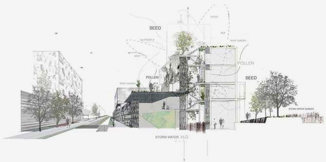
During earlier stages of the development and during main urban restructuring processes in the East, they are able to organise materialities, ranging from demolition fragments, rubble, clay covers to soil deposits. Some of the structures act as a store for these accumulated materials, in effect they become a temporal or transferable landscape, which can be displaced as required else where in London for reuse in restructuring. Furthermore the structures may act as storm water gardens and landscpe boundaries, during these stages. This space is characterised by specificity regarding the context and place where it is and the materials it is made of.
Section-perspective, Urban Development with Walls, Charlotte Harris, 2008
After being part of restructuring porcesses and serving as industrial landscape, the proposal may remain part of an ongoing material process, may become part of an articulated open space strategy or become the enabling foundations of urban city building processes.
The infrastructural intervention of the walls enable the formations of urban elements such as streets, publicspace, plots, building fabric and components, as these concepts are the foundations which the vision rests. With a new idea of urban-territorial frameworks more adaptable and sensitive to what pre-exists.
The infrastructural intervention of the plots, frames and walls - pertains to building infrastructures designed to flexibly accommodate development and increase density of mixed-uses as well as management by setting up a framework for land re-zoning, permeability and public space configurations.
Where the proposition is working with the process of urban colonisation of the landscape it provides the building components of plots, substructure of foundations, primary walls for infill development/attachments, and infrastructure/ service voids, whilst integrating vertical landscape and water management systems into potential urban developments.
They allow provision for accessibility, drainage, and services within the structure. The framework for primary structure is set-up for negotiating plot adjacencies as buffers and enables inhabitation in a configuration which can apt over time.
The structures are designed to attract various uses in time and to unify them. They could be seen as architectural infrastructure for the future communities and have been programmed with initial and long term uses.

Wall Structures, Surface Textures - Charlotte Harris 2008
2007-08 Jane Clossick
Jane Clossick - Thesis - Redevelopment of Rathbone Estate in Canning Town, London
MA Alternative Urbanisms - 2007/08 - Design and Theory Part, 18 June 2008

Rathbourne Estate from the A 13 - Jane Clossick 2007
The project explores an alternative approach to the redevelopment of dysfunctional city cul-de-sacs created by the broad sweeping and visionary planning of the 1960s. Focussing on the Rathbone Estate in Canning Town, the objective is to produce a prototype for the regeneration of council and ex-council estates, with both urban and building scale strategies and interventions. The proposal increases the autonomy of existing residents through new spatial, social and environmental management.
Access, Address and Buildings - Existing and Proposal - Jane Clossick, 2008
"...architecture has become too important to be left to the architects... therefore all barriers between builders and users must be abolished, so that builders and users become two different parts of the same planning process" (Giancarlo DeCarlo, 'Architecture's Public' 2006)
Through a simple system of extensions, the Rathbone can be regenerated without the need for complete decanting of existing residents. It can become a vital, sustainable and desirable part of cityspace. The process proposed consists of very small scale, selective demolition, the addition of new building typologies in between blocks and facade-like extensions to the existing buildings.The result is a navigable, legible piece of city, which becomes a route to this and other places. The density is increased, providing a critical mass of people to sustain various place specific and generalised programmes which will occupy the new, flexible range of typologies. The process of management, construction and procurement is participatory, ‘bottom up’ and offers residents a genuine stake in their area, and a real piece of profits to be gained from redevelopment.

The outcome of the process of extending the existing build urban form is the establishment of a prototype which integrates council estate regeneration, densification and the creation of functioning and flexible city space. The prototype could be applied to the myriad of similar estates all over London.
The increase in density in council estates, along with use of brownfield land already suggested in the London plan would negate the need for the vast expansion which is proposed for the Thames Gateway. If increase population can be accommodated within existing city fabric, rather than in new satellite towns, the existing infrastructure will be used to best effect. The critical mass of people will allow a broad range of self-supporting diversity, which is altogether a more ecologically and socially sound proposal for a sustainable future.

Estates in East London - Jane Clossick, 2008
2006-07 Tokushi Watanabe
Tokushi Watanabe - Thesis - Time-Based Access-Strategy for 2012 Olympics
MA Alternative Urbanisms - 2005/06 - Design and Theory Part, 06 February 2007
MA Alternative Urbanisms - 2005/06 - Design and Theory Part, 06 February 2007

Lea Valley images - Tokushi Watanabe 2007
1. Connectivity and Accessibility
The connection between the Olympic site and its surrounding area is insuficient now. In addition, since many blind passages exist in the surroundings, some areas are isolated there. Especially, the industrial area on the west side of the Olympic site lies between the river and the motorway. […] My proposition begins from increasing one access point through this industrial area. The Roman Road in the residential area is made to extend directly to the Olympic site by constructing two bridges over the motorway and the River Lea. […]By enhancing the connectivity and accessibility among three areas, the activity of the industrial area will also increase. Since security in the Olympic site is required during the Olympic event, many access points cannot be provided. However, after the Games, the Olympic site changes to a park. When the site constitutes a park, more accessibility between the residential area and the park will be required.

Lea Valley plan - Tokushi Watanabe 2007
2. Time Scenario
During the Games, ten stadiums will be built in the site and these total capacity amounts to about 170,000 seats, and as for the sum total of the visitor, 1.2 million visitors are expected. The access points to the site increase in number in accordance with this capacity. However, these Olympic facilities differ greatly in the plan between during the Games and after the Games. Five stadiums will be demolished and the total capacity of the remaining stadiums will also decrease to about 50,000 seats after the Games. It is planned that these facilities are used as Olympic legacies for neighbourhoods including the residents of 9,000 houses newly built in the site. […] My strategy is that the capacity and accessibility of the proposed pedestrian deck change according to the changes of the Olympic site by time. The conditions of the Olympic site change between before and after the Games.

Timber module access strategy - Tokushi Watanabe 2007
Before the Games, one of the requirements for the boundary of the Olympic site is that the isolated industrial area connects with the residential area and the Olympic site. The activity of the industrial area will be enhanced by improving the connectivity between the Roman Road in the residential area and the Lea Valley Walk in the Olympic site through the industrial area. It is considered that the users of the deck in this case are neighbourhoods and workers in the industrial area. The workers can go to lunch easily to the Roman Road, and neighbourhoods may go for a walk to the Lea Valley Walk during a weekend. Some activities will be induced in the isolated industrial area by providing bridges over the motorway and the River Lea.

During 2012 Olympics - Tokushi Watanabe 2007
During the Games, the requirement is that the connectivity between the residential area and the Olympic site is enhanced by expanding the scale of the deck. A large number of people will visit the Olympic site during this period. The deck is stretched directly from the residential area to the Olympic site so that the industrial area may be covered. Many factories and works in the surroundings were lost by the Olympic event. Therefore, without losing workplaces here, the deck is created using the roofs of buildings in order to enable many visitors access to the Olympic site. Under the deck, some new spaces are provided for the factories.
After the Games, since the number of the visitors to the Olympic park decreases, the scale of this deck is reduced as well as the stadiums. Instead, in order to make new access points to the Olympic park, new bridges are covered over the river. During the Games, the number of the access points to the Olympic site is restricted for safety. However, the site is modified to the park after the event, and the connectivity between the residential area and the park will be required more. The redundancy when decreasing the original deck is applied to the material of the new bridges [...]Neighbourhoods access into the industrial area, and the diversity of an activity will increase in this area, and this deck changes according to demands with time.

Phases - 2008 - 2012 Olympics - 2016, Tokushi Watanabe 2007